
Did you know that utility strikes cost the Australian economy an estimated $4.6 billion every year? With over 15,000 reported incidents annually across the country, the financial and human cost of subsurface damage has reached a critical threshold. For project managers in Queensland, preventing utility strikes on site is no longer just a safety checkbox; it’s a strategic necessity to avoid massive repair costs and legal liabilities. It’s a high-stakes environment where a single error can derail an entire development timeline.
We recognize that relying on indicative data often creates a false sense of security, leading to the very disruptions you’re trying to avoid. This article explains why standard site plans often fail and how you can implement a zero-strike safety strategy. We’ll debunk five dangerous myths that compromise site safety and explore how advanced locating technology ensures compliance with AS 5488.1:2022 standards for a faster, more secure site handover.
Key Takeaways
- Understand why Before You Dig Australia (BYDA) plans are merely indicative and why their inherent spatial inaccuracies require physical verification to protect project timelines.
- Master the application of AS 5488 standards to classify subsurface data, ensuring your team speaks the industry language of risk management through defined Quality Levels.
- Compare the safety profiles of traditional digging against vacuum excavation to see how non-destructive methods significantly reduce the probability of service disruptions.
- Implement a structured zero-strike workflow that integrates professional utility locating and GPR mapping for preventing utility strikes on site.
- Transition toward a Subsurface Utility Engineering (SUE) model that combines engineering surveying and planning to ensure long-term infrastructure integrity.
The Dial Before You Dig Fallacy: Why Plans Aren’t a Shield
A common misconception in the civil industry is that a Before You Dig Australia (BYDA) search provides an exhaustive inventory of everything beneath the surface. This myth suggests that if a service doesn’t appear on the official plan, it simply doesn’t exist underground. In reality, legacy plans are historical documents rather than real-time maps. They often contain spatial accuracy errors of several metres, which makes preventing utility strikes on site impossible if you rely on paperwork alone.
Under Queensland safety legislation, specifically the Work Health and Safety Act 2011, site managers hold a non-delegable duty of care to ensure the safety of workers and the public. Relying on indicative plans does not satisfy this legal obligation. When a strike occurs, “the plans didn’t show it” is rarely an acceptable legal defense. True risk mitigation requires moving beyond the initial search stage into active physical verification and strategic oversight.
The Difference Between a Plan and a Reality
Standard utility plans are often decades old and were recorded during a time when surveying standards were less rigorous. Over time, ground movement, soil erosion, and subsequent site works can significantly shift the actual position of a pipe or cable. It is essential to understand that utility location is a dynamic process because providers are not legally liable for the inaccuracies in the plans they provide. They offer these records as a guide only, placing the burden of physical identification squarely on the project team. A professional approach treats these plans as clues rather than certainties.
Why Private Assets Are the Silent Site Killer
Perhaps the most dangerous gap in official records is the “ghost utility” or private asset. BYDA searches generally only return data for assets owned by major utility providers. They do not include fire services, internal power grids, or data lines installed by previous owners within the property boundary. These private assets are the cause of many unexpected disruptions and safety incidents. To capture these hidden risks, sophisticated engineering surveying brisbane is required to map the entire site ecosystem. Without this strategic foresight, you are essentially digging into the unknown, regardless of how many official plans you have in your hand. This meticulous approach is the only way to ensure total site integrity and successful project delivery.
The Science of Subsurface Uncertainty: AS 5488 Explained
The Australian Standard AS 5488.1:2022 provides the technical framework for classifying subsurface utility information (SUI). It transforms the chaotic nature of underground records into a disciplined, data-driven methodology. For project managers, this standard is the primary tool for preventing utility strikes on site because it provides a clear metric for data reliability. Instead of guessing the location of a pipe, teams can now assign a “Quality Level” to every asset on their map, allowing for more informed decisions regarding excavation methods and safety setbacks.
Decoding Quality Levels: From D to A
Understanding the hierarchy of risk is essential for any civil project. Quality Level D is the absolute baseline. It relies solely on desktop records and historical plans, which we’ve established can be dangerously inaccurate. Quality Level B represents the current industry standard for safety. It utilizes surface geophysical detection to map assets without breaking ground. Finally, Quality Level A is the gold standard of certainty. It requires the physical exposure of the utility, typically via vacuum excavation, to confirm its precise horizontal and vertical coordinates. Moving from D to A is the strategic process of stripping away uncertainty.
Geophysics vs. Guesswork
Modern site investigations rely on the synergy of Ground Penetrating Radar (GPR) and Electromagnetic Induction (EMI). While EMI is exceptional for detecting metallic lines by tracing an active or passive electromagnetic signal, GPR is the only reliable way to identify non-metallic assets like PVC water mains or fibre optic conduits. It works by sending high-frequency radio pulses into the ground and measuring the reflections from buried objects.
However, technology isn’t a silver bullet. In the highly conductive clay soils frequently encountered across Brisbane, GPR signals can attenuate rapidly, losing depth penetration. This is why a multi-sensor approach is vital; relying on a single tool creates blind spots that lead to strikes. Adhering to damage prevention best practices means moving beyond the “scan and dig” mentality. By integrating these standards into your project lifecycle, you move from reactive repairs to proactive asset management. For projects requiring this level of technical rigor, engaging experts in underground utility locating ensures your data meets the highest compliance standards and protects your timeline from the unexpected.
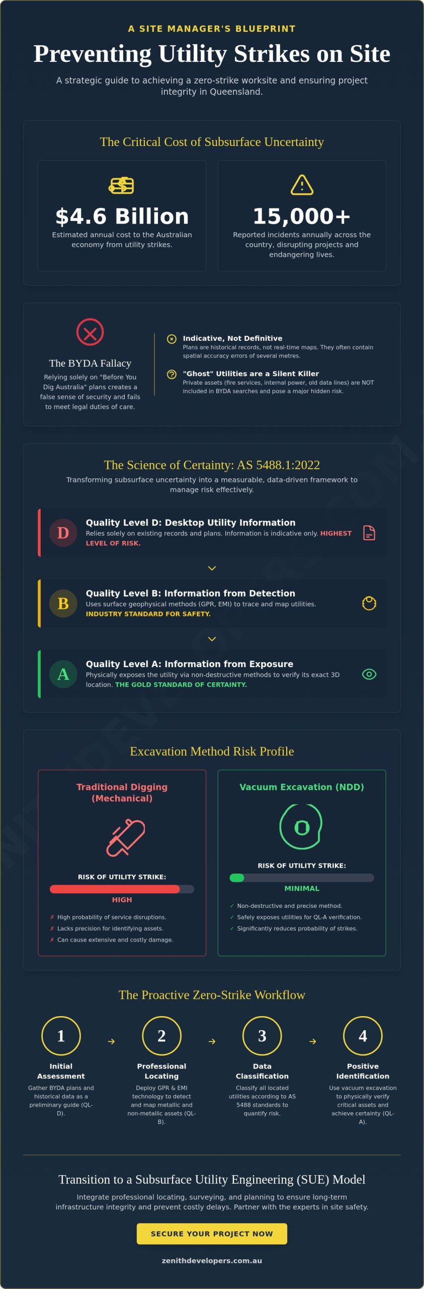
Vacuum Excavation (NDD) vs. Traditional Digging: A Risk Comparison
The belief that hand digging represents the pinnacle of site safety is a legacy mindset that no longer aligns with the complexities of modern infrastructure. While manual excavation is often viewed as a cautious approach, it remains physically demanding and carries a high probability of accidental damage to delicate fibre optic coatings or gas line tracers. Transitioning to vacuum excavation, also known as Non-Destructive Digging (NDD), represents a strategic shift toward a more systematic and reliable method for preventing utility strikes on site. By utilizing pressurized water or air to displace soil, this technology ensures that assets remain untouched while the surrounding ground is removed.
A calculated cost-benefit analysis reveals that the investment in NDD is a form of project insurance. While traditional methods might seem cheaper on a daily rate, they don’t account for the catastrophic financial impact of a utility strike. With the Australian economy losing billions annually to subsurface damage, the choice to use advanced vacuum technology is an exercise in foresight. It protects not only the physical assets but also the project’s reputation and the safety of every worker on the ground.
Why Mechanical Excavators Fail in High-Risk Zones
Mechanical excavators are engineered for bulk power, not haptic sensitivity. Modern hydraulic systems lack the “feel” required for an operator to distinguish between a stubborn rock and a high-pressure water main. By the time a spotter identifies a conflict, the momentum of the bucket has often already caused a breach. In high-risk zones, the presence of bucket teeth poses a constant threat to gas mains and high-voltage conduits, where even a minor scrape can lead to an emergency shutdown or a life-threatening incident.
The Advantages of Hydro Excavation
Hydro excavation offers a level of precision that is impossible to replicate with traditional machinery, particularly in congested urban environments like the Gold Coast. This method allows for surgical trenching and potholing, enabling teams to expose services with zero risk of mechanical impact. It also eliminates the danger of electrical arcing when working near high-voltage cables, as the process involves no conductive metal contact with the utility. Beyond safety, it promotes cleaner site management by containing all spoil within the vacuum unit, which reduces the environmental footprint and streamlines the handover process. Integrating vacuum excavation into your workflow ensures that the final stage of service verification is as rigorous as the initial planning phase.
The Zero-Strike Workflow: A Blueprint for Site Managers
Achieving a zero-strike outcome requires more than just caution; it demands a structured, multi-layered workflow that eliminates reliance on guesswork. By treating subsurface data as a dynamic project asset rather than a static plan, site managers can move from a reactive posture to one of strategic control. This methodical approach is the most effective way of preventing utility strikes on site, ensuring that every phase of excavation is backed by verified spatial data. A truly robust workflow follows five critical steps of verification.
- Step 1: Quality Level D. Conduct a comprehensive Before You Dig Australia (BYDA) search and desktop review to identify the likely presence of major utility corridors.
- Step 2: Quality Level B. Engage professional utility locating services to perform surface geophysical detection using Ground Penetrating Radar and electromagnetic induction.
- Step 3: Surveying. Capture the identified signals through high-precision engineering surveying to anchor utility positions to the project’s coordinate system.
- Step 4: Quality Level A. Execute Non-Destructive Digging (NDD) potholing to achieve positive identification and visual confirmation of the asset’s depth and orientation.
- Step 5: Ongoing Monitoring. Implement a permit-to-work system that requires a final check against the site map before any bucket hits the ground.
Integrating CCTV Inspection for Drainage Safety
While GPR is highly effective for many assets, it often struggles with deep-buried stormwater and sewer lines, particularly in dense or saturated soils. To bridge this gap, integrating CCTV pipe inspection into the workflow allows for the visual verification of internal pipe conditions and precise location of voids. This is a critical step for preventing cross-bore incidents during directional drilling operations, where a new service might otherwise inadvertently pierce an existing sewer line. Visual data provides the certainty that geophysical signals alone sometimes cannot reach.
The Importance of Permanent Site Marking
Spray paint is not a long-term safety strategy. On multi-year infrastructure projects, temporary marks fade, get covered by soil, or are washed away by Queensland’s heavy rain. A professional workflow involves translating these marks into a digital twin of the site. By utilizing site investigation services, developers create a lasting safety record that survives the entire construction lifecycle. This digital record acts as a permanent reference point for all contractors, reducing the need for repeated locating and ensuring that preventing utility strikes on site remains a consistent priority until the project is handed over. To secure your next development against subsurface risks, consider partnering with Zenith Developers for comprehensive utility management and surveying expertise.
Strategic Foresight: Why Zenith Developers is the Site Safety Partner
Modern infrastructure projects require a shift from reactive locating to the disciplined methodology of Subsurface Utility Engineering (SUE). At Zenith Developers, we view the underground environment as a complex data ecosystem that demands more than just a mark on the ground. By integrating engineering surveying, town planning, and advanced locating into a single, cohesive workflow, we provide the strategic foresight necessary for preventing utility strikes on site. This holistic approach ensures that every piece of subsurface data is verified, mapped, and anchored to your project’s broader objectives.
Our methodology is built on the quiet authority of technical expertise and a commitment to intellectual rigor. We don’t just identify pipes; we facilitate the seamless transformation of raw land into sophisticated developments. By aligning our underground utility locating with cadastral surveying, we ensure that every asset is accounted for within its legal and physical boundaries. This level of precision protects your professional reputation and secures your bottom line against the volatility of service disruptions in the Queensland market.
Advanced Technology for Complex Sites
We utilize a suite of high-resolution technologies tailored to the specific geological challenges of the Brisbane and Gold Coast regions. Our high-resolution concrete scanning services ensure structural integrity is maintained during penetrations, while our vacuum excavation units provide the final, non-destructive confirmation required for Quality Level A data. We understand that Brisbane’s conductive clay soils can hinder standard equipment, which is why we employ a multi-sensor approach. Combining Ground Penetrating Radar with electromagnetic induction and CCTV pipe inspection allows us to build a comprehensive site map that leaves no room for guesswork. This technological depth is essential for preventing utility strikes on site when working in high-density urban corridors.
The Value of Meticulous Preparation
The true value we bring to a project lies in the intellectual preparation that occurs before a single machine arrives. Our town planning expertise allows us to navigate the complex regulatory safety requirements and easement restrictions that often complicate large-scale developments. This foresight reduces on-site execution risks and prevents the costly delays associated with unmapped private assets or legacy infrastructure. We believe that a well-planned project is a safe project, and our integrated service model is designed to provide that stability from inception to handover. You can secure your site with Zenith’s professional utility locating services to ensure your next project is defined by precision and professional excellence.
Secure the Future of Your Project Infrastructure
The complexity of Queensland’s underground infrastructure requires a transition from passive observation to active, data-driven management. By debunking the myths surrounding indicative plans and embracing the technical rigor of the AS 5488 standard, project managers can eliminate the uncertainty that leads to costly disruptions. Implementing a zero-strike workflow isn’t just about safety; it’s a strategic investment in the long-term viability and reputation of your development.
Zenith Developers has been a steady hand for the civil industry since 2015, providing the foresight and precision needed for preventing utility strikes on site across Brisbane and the Gold Coast. Our commitment to certified AS 5488 compliance and the latest GPR and vacuum excavation technology ensures your project remains on schedule and within budget. We invite you to Partner with Zenith Developers for Comprehensive Underground Utility Locating. Let’s work together to transform subsurface uncertainty into a foundation for professional excellence and project success.
Frequently Asked Questions
What is the most common cause of utility strikes on construction sites?
The primary cause of utility strikes is an over-reliance on indicative site plans without physical verification. Many operators assume that if a service isn’t listed on a Before You Dig Australia (BYDA) search, the ground is clear. This lack of active subsurface investigation, combined with inadequate site marking, leads to the majority of accidental damages during excavation.
Is Before You Dig Australia (BYDA) a legal requirement for all excavations in QLD?
Obtaining plans via BYDA is a fundamental legal requirement under Queensland’s Work Health and Safety legislation. Site managers must take all reasonable steps to identify underground services before commencing work. While the search is a critical first step, it’s only the beginning of a compliant safety strategy for preventing utility strikes on site.
How accurate is Ground Penetrating Radar (GPR) for locating plastic pipes?
GPR is highly effective at identifying non-metallic assets like PVC and fibre optics by detecting changes in soil density. Its accuracy is influenced by soil conditions; it performs exceptionally well in sandy soils but may encounter signal attenuation in high-conductivity clays. Professionals use GPR to provide a non-invasive view of the subsurface that electromagnetic induction cannot capture.
What should I do immediately if a utility strike occurs on my site?
You must immediately cease all works and evacuate the area if the strike involves high-pressure gas or high-voltage electricity. Once the site is secure, you’re legally required to contact the asset owner and report the incident to Workplace Health and Safety Queensland. Documenting the site conditions and the specific location of the strike is essential for subsequent investigations.
How much does professional utility locating cost compared to potential strike fines?
Professional locating represents a minor project expense compared to the massive financial penalties and repair costs associated with a strike. Fines for safety breaches in Australia can reach tens of thousands of dollars, while the cost of project downtime and emergency repairs often exceeds the original project margin. Strategic investment in locating is a form of financial risk management.
What is Non-Destructive Digging and when is it mandatory?
Non-Destructive Digging (NDD), or vacuum excavation, is a method of removing soil using high-pressure water or air to expose utilities safely. It’s often mandatory when excavating within the specified “clearance zones” of high-priority assets like high-pressure gas mains. Many utility providers require visual confirmation via NDD before any mechanical excavation can occur nearby.
How often should site utility marks be refreshed or verified?
Site marks should be verified at the start of every new project phase or after significant weather events like heavy rain. Temporary markings can fade or be obscured by soil movement and site traffic. Maintaining a digital twin or surveyed site map ensures that the location of assets remains clear even when physical surface marks are lost.
Can Zenith Developers provide AS 5488 compliant utility maps?
Zenith Developers provides comprehensive utility mapping that adheres strictly to the AS 5488.1:2022 standard for subsurface utility information. Our integrated approach combines underground utility locating with engineering surveying to deliver high-precision digital records. These maps provide the clarity required for preventing utility strikes on site and ensure your project meets all regulatory safety benchmarks.