
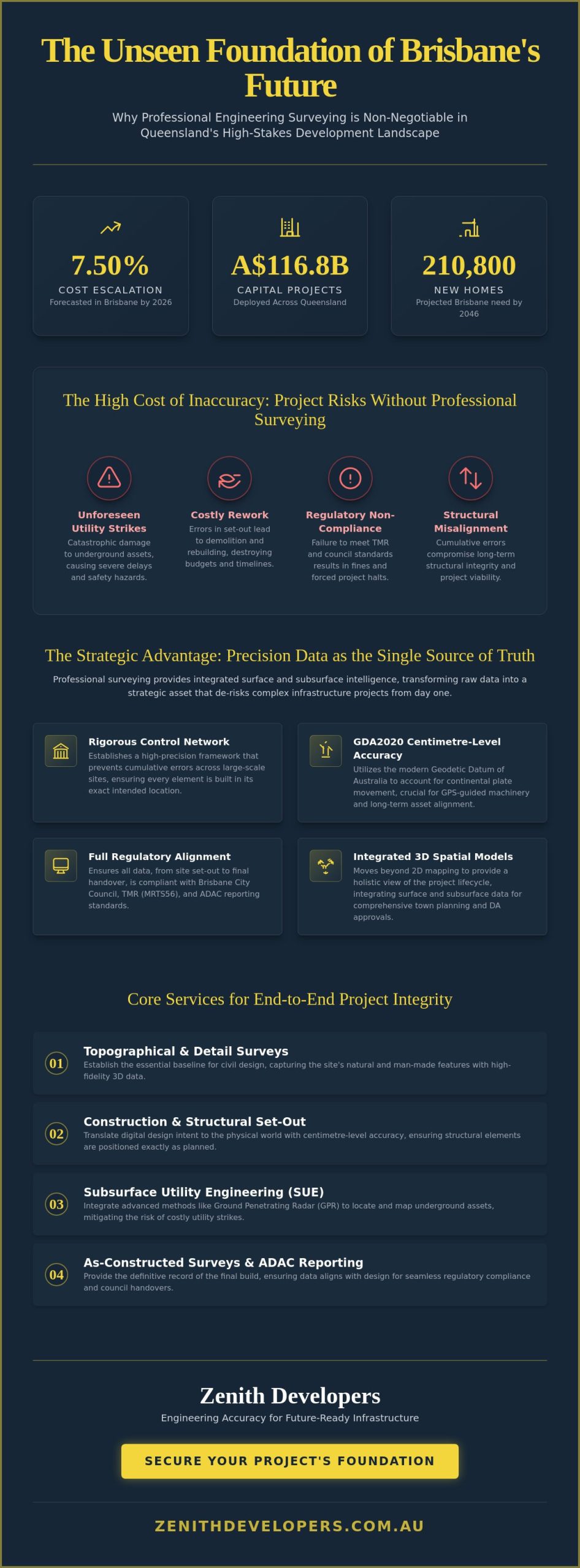
With Brisbane’s construction cost escalation forecasted to hit 7.50% in 2026, the margin for error on major infrastructure has effectively vanished. You’re likely aware that in a landscape where over A$116.8 billion in capital projects is being deployed across Queensland, a single inaccurate set-out or an unforeseen utility strike can derail months of momentum. In this high-stakes environment, professional engineering surveying brisbane isn’t merely a measurement task; it’s the strategic foundation that prevents project failure through integrated surface and subsurface intelligence.
We understand the pressure of navigating complex TMR surveying standards and the necessity of zero-error structural elements. This article reveals how professional surveying provides the strategic data and risk mitigation required for successful Brisbane developments. You’ll discover how we utilize advanced methodologies to eliminate costly rework, ensure seamless ADAC reporting for council handovers, and provide full protection for existing underground assets through meticulous foresight and technical rigor. By aligning precise data with regulatory requirements, we ensure your project moves from vision to completion without the burden of avoidable delays.
Key Takeaways
- Precision data serves as the single source of truth for site managers, providing the strategic clarity needed to de-risk complex urban infrastructure projects.
- Professional engineering surveying brisbane establishes the essential baseline for civil design, ensuring that high-precision construction set-outs maintain long-term structural integrity.
- Traditional land surveys are often incomplete without subsurface utility engineering; learn how integrating utility locating mitigates the risks associated with unforeseen underground assets.
- Selecting a partner with the appropriate Queensland licensing and advanced technical capabilities, such as GPR and LiDAR, is vital for regulatory compliance and site safety.
- A holistic approach to site investigation facilitates seamless handovers to local councils by aligning technical rigor with accurate ADAC reporting standards.
The Strategic Significance of Engineering Surveying in Brisbane’s Development
Brisbane’s urban landscape is undergoing a profound metamorphosis, driven by a projected need for 210,800 new homes by 2046 and a massive A$116.8 billion infrastructure pipeline. In this high-velocity environment, engineering surveying brisbane serves as the primary mechanism for de-risking projects that are often hemmed in by existing utilities and rigid boundary constraints. By establishing a precise spatial framework from the outset, developers can mitigate the financial exposure associated with structural misalignment and regulatory non-compliance. Professional surveying provides several strategic advantages:
- It establishes a rigorous control network that prevents cumulative errors across large-scale sites.
- It ensures all civil and structural elements align perfectly with existing cadastral boundaries.
- It provides the data necessary to navigate the complex topography of the Brisbane River catchment.
- It facilitates the integration of new assets into the city’s digital twin models.
For site managers, high-fidelity data acts as the single source of truth, ensuring that every contractor on a multi-disciplinary site works from the same coordinate system. This is particularly vital following the implementation of the Geodetic Datum of Australia (GDA2020). This modern datum accounts for the ongoing movement of the Australian plate, providing the centimetre-level accuracy required for sophisticated GPS-guided machinery. To understand the foundational principles of this field, one might ask What is Surveying? and how its evolution from simple measurement to complex data management enables today’s massive civil undertakings. Strategic foresight in these early stages reduces long-term liability by ensuring that as-constructed data matches design intent with absolute fidelity.
Navigating Brisbane’s Evolving Infrastructure Landscape
Surveying in Brisbane presents unique challenges, from the high-density urban corridors of the CBD to the complex alluvial soils near the river. Accurate data must align with stringent Brisbane City Council and Department of Transport and Main Roads (TMR) requirements, such as the MRTS56 Construction Surveying standards. Our approach integrates local terrain factors with regulatory awareness, ensuring that site data is not only precise but also compliant with the latest April 2026 updates to Queensland’s surveying standards. We don’t just record points; we interpret the physical landscape to protect your project’s viability.
From Vision to Execution: The Surveyor as a Strategic Partner
Early involvement of engineering surveyors is the most effective way to prevent design-phase errors that lead to costly rework. We’ve moved beyond traditional 2D mapping, instead providing integrated 3D spatial models that offer a holistic view of the project lifecycle. This high-level data informs town planning and Development Application (DA) approvals, allowing for a smoother transition from conceptual vision to physical execution. By treating engineering surveying brisbane as an intellectual partnership rather than a transactional service, developers secure the integrity of their investment from day one.
Essential Surveying Services for Civil and Structural Projects
Large-scale civil works demand a seamless transition from high-level strategy to granular execution. While topographical surveys establish the necessary baseline for civil design, the ongoing management of a site requires dynamic, high-frequency data. For instance, volumetric calculations for earthworks and stockpile management aren’t just about moving soil; they’re about maintaining the project’s financial and logistical equilibrium. As a project nears its final stages, as-constructed surveys provide the definitive record required for regulatory compliance and formal close-out. Within the competitive landscape of engineering surveying brisbane, these services ensure that the physical build mirrors the digital intent with absolute fidelity.
Construction Set-Outs and Control Networks
Precision begins with the establishment of robust primary and secondary control networks across the site. These networks ensure that every element, from bridge abutments to tunnel headings, maintains perfect horizontal and vertical alignment throughout the construction lifecycle. For Tier 1 civil works, critical structural elements typically require tolerance levels within a 5mm to 10mm range to ensure long-term load-bearing integrity. Engaging with professionals aligned with the Australasian Institute of Engineer Surveyors ensures your project adheres to these rigorous professional standards and technical benchmarks.
ADAC Compliance and Council Asset Handover
In Queensland, the handover of public assets like stormwater, road networks, and sewerage systems requires strict adherence to Asset Design As Constructed (ADAC) standards. This digital XML-based reporting format streamlines the transfer of spatial data to local authorities, yet it remains a frequent source of project friction. Many developments face significant delays during the final phase due to inconsistent data schema or incomplete attribute fields in their reporting. By integrating ADAC requirements into the data collection phase of your engineering surveying brisbane workflow, you ensure a seamless transition to council ownership without the need for expensive data correction.
Quality Assurance (QA) and Conformance Reporting
Quality Assurance isn’t a mere formality; it’s a strategic risk management necessity. We provide independent verification that completed works match the original engineering design specifications, generating detailed conformance reports that protect stakeholders and insurers alike. These reports are invaluable for dispute resolution, providing an empirical, legally defensible record of exactly what was built. If you’re looking to secure your project’s future, considering an integrated approach to engineering surveying can prevent costly discrepancies before they ever reach the construction phase. This meticulous verification process ensures that every structural element is fit for purpose and compliant with all relevant Queensland safety standards.
Mitigating Subsurface Risks: Integrating Surveying with Utility Locating
The complexity of Brisbane’s subterranean environment demands more than just surface-level data. While traditional land surveying provides the necessary topographical context, it remains fundamentally incomplete without the integration of Subsurface Utility Engineering (SUE). Relying on Dial Before You Dig (DBYD) records is a common but dangerous oversight; these documents are often outdated or spatially inaccurate, serving only as a preliminary guide rather than a definitive source of truth. In high-risk construction zones, the difference between a successful excavation and a catastrophic utility strike often lies in the quality of the subsurface intelligence gathered before a single machine arrives on site.
We utilize Ground Penetrating Radar (GPR) and electromagnetic induction to peer into the earth, identifying both metallic and non-metallic services that historical plans might miss. This intelligence is then seamlessly translated into the broader engineering surveying brisbane framework, creating a multi-dimensional site model that accounts for every variable. To guarantee the exact location of critical assets, we employ non-destructive vacuum excavation. This method safely exposes utilities using pressurized water and high-volume suction, providing the physical confirmation required for high-precision works without the risk of mechanical damage to existing infrastructure.
The AS 5488-2019 Standard for Utility Classification
AS 5488-2019 provides a standardized framework for classifying the quality of underground asset information, ranging from Quality Level D (basic records research) to Quality Level A (physical validation). Quality Level A, achieved through potholing, is the only method that provides the absolute spatial certainty necessary for Tier 1 infrastructure projects. Zenith Developers aligns all surveying data with these Australian Standards, ensuring that every point on our plans carries a verified level of reliability. This methodical approach transforms subsurface uncertainty into a manageable project variable, allowing for informed decision-making during the design and construction phases.
Visualising the Invisible: 3D Utility Mapping
Visualizing these hidden networks requires a sophisticated array of diagnostic technologies. We integrate CCTV pipe inspection data to map the internal condition and precise alignment of drainage systems, while concrete scanning identifies post-tension cables and rebar within existing slabs or piers. By merging these disparate datasets into a unified 3D utility map, we significantly reduce the strike rate of underground services. This integrated perspective allows site managers to navigate the subsurface with the same confidence they have on the surface, ensuring that the engineering surveying brisbane data provides a complete and reliable picture of the entire project environment.
Selecting an Engineering Surveying Partner in Queensland
Selecting a partner for engineering surveying brisbane requires a focus that extends beyond basic measurement capabilities. It involves evaluating a firm’s alignment with Queensland’s specific regulatory environment and their ability to provide a strategic data framework. In this state, the distinction between cadastral and engineering endorsements is critical; ensuring your partner is registered with the Surveyors Board of Queensland is a fundamental step in de-risking your project. A firm’s established track record with the Brisbane City Council and the Department of Transport and Main Roads (TMR) indicates a practical understanding of local compliance standards, such as MRTS56, which are essential for successful infrastructure delivery.
A multidisciplinary approach provides a distinct strategic advantage that siloed firms cannot match. When a single entity manages cadastral surveying, town planning, and underground utility locating, the resulting data is cohesive and actionable. This integration prevents the communication gaps that often lead to design-phase errors or unforeseen site constraints. By unifying surface and subsurface intelligence, a multidisciplinary partner ensures that the intellectual preparation behind the work is as robust as the technical execution itself.
Technical Proficiency and Equipment Standards
Modern infrastructure projects demand high-accuracy robotic total stations and Global Navigation Satellite System (GNSS) receivers to maintain the tight tolerances required for Tier 1 civil works. These instruments allow for real-time data capture and centimetre-level precision, which are vital when working within the high-density corridors of the CBD. Professional indemnity insurance is another non-negotiable requirement, providing a layer of security that reflects the firm’s commitment to professional accountability. You should always verify a surveyor’s specific experience with local geodetic datums like GDA2020 to ensure your site coordinates are future-proofed and accurate over the long term.
The Procurement Checklist for Site Managers
Effective procurement begins with a clear understanding of the project’s technical needs. Following a structured checklist ensures that your chosen partner can meet the rigorous demands of Brisbane’s infrastructure landscape:
- Step 1: Define the required quality levels and spatial tolerances based on AS 5488-2019 standards for utility and surface data.
- Step 2: Verify local project experience and safety certifications, particularly for high-risk environments or large-scale public works.
- Step 3: Confirm that data delivery formats, such as BIM, CAD, and ADAC, are fully compatible with your existing project management and design software.
To ensure your next project is built on a foundation of absolute accuracy and regulatory compliance, consult with our team for professional engineering surveying services tailored to the unique requirements of the Brisbane market.
Zenith Developers: Engineering Accuracy for Future-Ready Infrastructure
Zenith Developers positions engineering surveying brisbane as a high-level consultancy rather than a transactional necessity. We recognize that the success of Queensland’s A$116.8 billion infrastructure pipeline depends on the intellectual preparation behind every measurement. By combining technical rigor with strategic foresight, we provide a steady hand for developers navigating the physical and regulatory complexities of the region. Our methodology ensures that every project is built on a foundation of practical reliability and long-term viability, allowing our partners to focus on growth while we manage the spatial risks.
Our integrated approach to site investigation eliminates the traditional silos between surface data and subsurface intelligence. When engineering surveying is aligned with underground utility locating and vacuum excavation, the result is a comprehensive model that protects existing assets while streamlining new construction. This meticulous data management is vital for supporting the rapid growth of South East Queensland. We partner with our clients to transform complex site variables into clear, actionable strategies that ensure project momentum remains uninterrupted and compliant with all local standards.
The Zenith Methodology: Precision Meets Strategy
We maintain a steadfast commitment to the highest professional and regulatory standards, including the latest TMR and MRTS56 specifications updated in April 2026. A key differentiator in our process is how we integrate town planning insights directly into the surveying workflow. This ensures that the data we capture is already optimized for DA approvals and council compliance. In a recent major civil project in Brisbane’s inner north, our team identified a critical misalignment between historical utility plans and actual field conditions during the preliminary site investigation. By resolving this discrepancy before the design was finalized, we prevented what would have been a three-week delay and significant rework costs during the excavation phase.
Securing Your Site’s Future Success
Our cerebral approach to surveying delivers superior project outcomes because we prioritize accuracy and integrity above rapid, short-term gains. We understand that a project’s future success is dictated by the quality of its baseline data. If you’re ready to de-risk your development and ensure a seamless handover to local authorities, our Brisbane team is prepared to facilitate a comprehensive site investigation tailored to your specific objectives. We invite you to Enquire with Zenith Developers for your next infrastructure project to experience the clarity that comes from professional spatial intelligence and a partnership-oriented mindset.
Securing Brisbane’s Infrastructure Legacy
The complexity of modern civil works requires a shift from simple measurement to comprehensive spatial intelligence. By integrating surface data with subsurface utility engineering, developers can effectively eliminate the risks of structural misalignment and unforeseen asset strikes. Adhering to rigorous standards like AS 5488 and ADAC ensures that every project phase remains compliant and ready for seamless council handover. Professional engineering surveying brisbane provides the steady hand necessary to navigate these technical and regulatory demands with absolute confidence.
Zenith Developers brings a multidisciplinary perspective to every site, combining expertise in surveying, town planning, and utility locating to ensure long-term project viability. Our commitment to meticulous data management and professional integrity has established a proven track record across Queensland’s most significant developments. It’s this dedication to foresight that protects your investment from day one. We invite you to Partner with Zenith Developers for Strategic Engineering Surveying and secure the accuracy your next project deserves. Together, we can build a more precise and resilient future for our city.
Frequently Asked Questions
What is the difference between land surveying and engineering surveying?
Land surveying primarily focuses on the legal definition of property boundaries and land ownership through cadastral records. In contrast, engineering surveying is dedicated to the precise spatial positioning of infrastructure elements during the construction process. It ensures that civil works, such as bridge abutments and road alignments, are built exactly where the engineering design specifies, maintaining structural integrity throughout the project lifecycle.
How much does an engineering survey cost in Brisbane?
The cost of an engineering survey is determined by the specific scale, site complexity, and technical requirements of your infrastructure project. Factors such as the required level of precision for structural elements and the density of the surrounding urban environment will influence the final scope of work. Because every civil project presents unique challenges, it’s best to request a tailored fee proposal based on your specific design specifications and site conditions.
Why is ADAC compliance necessary for Brisbane developments?
ADAC compliance is a mandatory digital reporting standard required for the formal handover of new public assets to local authorities like the Brisbane City Council. This XML-based format ensures that data regarding stormwater, sewerage, and road networks is consistent and easily integrated into municipal records. Without accurate ADAC reporting, developers often face significant delays in project close-out and the final release of municipal bonds.
Can engineering surveyors identify underground utilities?
Yes, engineering surveyors can identify underground utilities by utilizing integrated subsurface utility engineering techniques. By combining traditional spatial data with technologies like Ground Penetrating Radar and electromagnetic induction, they create a comprehensive 3D site model. Professional engineering surveying brisbane services often include these methods to mitigate the risk of utility strikes and protect critical existing infrastructure during the excavation phase.
What equipment is typically used for engineering surveying in Queensland?
Modern surveying in Queensland utilizes high-accuracy robotic total stations, GNSS receivers, and 3D laser scanners to capture precise spatial data. These advanced tools allow for centimetre-level accuracy and real-time integration with BIM and CAD software. For subsurface investigations, surveyors also employ ground penetrating radar and electromagnetic locators to map underground assets according to the AS 5488-2019 Australian Standards.
How long does it take to complete a construction set-out survey?
A construction set-out survey can take anywhere from a few hours to several days depending on the number of points required and the site’s accessibility. While a simple building footprint might be completed in a single morning, complex civil projects require ongoing involvement. Large-scale works often involve hundreds of control points for roads or bridges that must be established across multiple stages of the construction lifecycle.
What happens if a surveyor makes a mistake on a construction site?
Errors in surveying can lead to structural misalignment, regulatory non-compliance, and expensive rework that derails project momentum. To prevent these outcomes, professional firms maintain rigorous quality assurance protocols and carry substantial professional indemnity insurance. If a discrepancy is identified, an independent QA survey is typically performed to resolve the issue and provide an empirical, legally defensible record for dispute resolution.
Is a cadastral survey required for engineering projects in Brisbane?
A cadastral survey is often required at the commencement of an engineering project to establish legal property boundaries. This ensures that all proposed infrastructure is contained within the correct land parcels and complies with mandatory setback requirements. Integrating engineering surveying brisbane with cadastral data prevents boundary encroachments and ensures that the physical construction aligns perfectly with legal land titles and local council regulations.